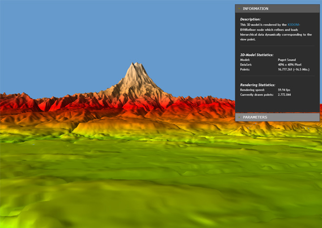
This tutorial describes he BVHRefiner component and how to use it to load and refine hierarchical data dynamically during runtime. Two different dataset structures can be used (WMTS, TREE) that are described later.
If you are just here to get the BVHRefiner Dataset Converter click here.
	<BVHRefiner maxDepth='5'
            minDepth='2'
            interactionDepth='4'
            subdivision='64 64'
            size='4096 4096'
            factor='10'
            maxElevation='410'
            elevationUrl="Puget Sound WMTS/elevation"
            textureUrl="Puget Sound WMTS/satellite"
            normalUrl="Puget Sound WMTS/normal"
            elevationFormat='png'
            textureFormat='png'
            normalFormat='png'
            mode="3d"
            submode="wmts">
	</BVHRefiner>
The following table lists the parameters currently supported:
| Parameter | Values | Default | Description |
|---|---|---|---|
| maxDepth | 0, 1, ... n | 3 | maximum depth of the tree, or dataset |
| minDepth | 0, 1, ... n | 0 | minimum depth of tree that should be rendered as soon as possible |
| interactionDepth | 0, 1, ... n | maxDepth | maximum rendered depth during user interaction with scene |
| subdivision | 0, 1, ... 125 | 1 1 | resolution of a rendered tile |
| size | 0, 1 ... n | 1 1 | size of the entire terrain |
| factor | 0, 1, ... n | 1.0 | factor affects the distance to create or render the next level (the higher the higher the performance, the lower the higher the quality) |
| maxElevation | 0.0, 0.1, ... n | 1.0 | maximum displacement in y direction |
| elevationUrl | string | “” | Url to dataset of displacement data |
| textureUrl | string | “” | Url to dataset of surface texture data |
| normalUrl | string | “” | Url to dataset of normal data |
| elevationFormat | png, jpg, gif ... | png | Data format of displacement dataset |
| textureFormat | png, jpg, gif ... | png | Data format of surface texture dataset |
| normalFormat | png, jpg, gif ... | png | Data format of normal dataset |
| mode | 2D, 3D, bin, bvh | 3D | 2D (planes), 3D (displaced y-coordinate of 2D-Planes), bin (binary files, WMTS), bvh (binary files, TREE) |
| submode | WMTS, TREE | WMTS | utilized dataset (WMTS, TREE (currently only in 2D mode)) |
We support two different types of datasets. The first is based on WMTS specification and the second version is a folder based file arrangement. In the 3D case, only the wmts format is supported. Both, the usage of WMTS and TREE for this BVHRefiner node are specified in the following subsections.
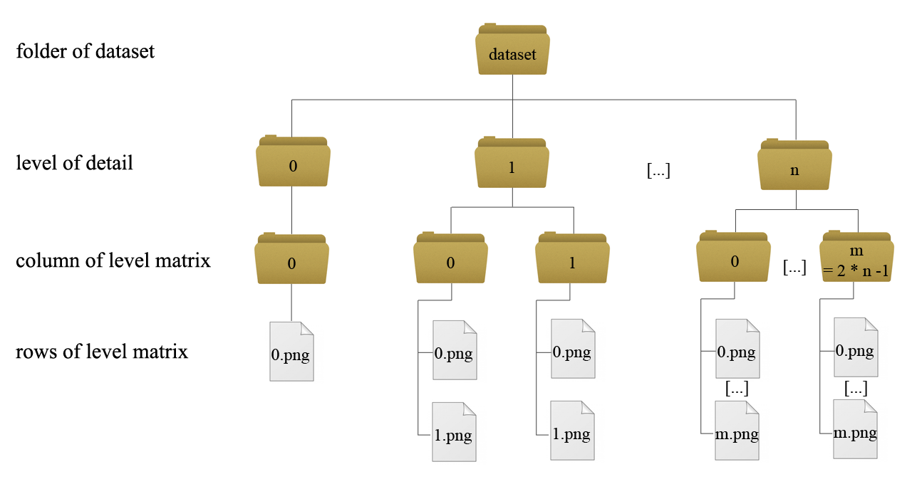
In WMTS a multidimensional dataset of a terrain can be integrated very easy. For every level of detail a new matrix of tiles is required. Every level has its own folder. So if you want to get five different levels of detail in your application, five folders must exist, numbered from 0 to 4. The detail from level to level grows up by a factor of four. Into the folders for the levels, subfolders that describe the columns of the matrix have to be inserted. On level 0 you only have one column, represented through the folder with the name 0. In the next level you have two columns named 0 and 1, growing up by a factor of two from level to level. In the subfolders you place the images that represent the tiles data. There must be as much images as subfolders. On level 0 you only have one image that represents the whole terrain data. On level one exist two subfolders. Every subfolder has to include two images, on the next level four per subfolder and so on. The following figure shows the addressing-scheme:
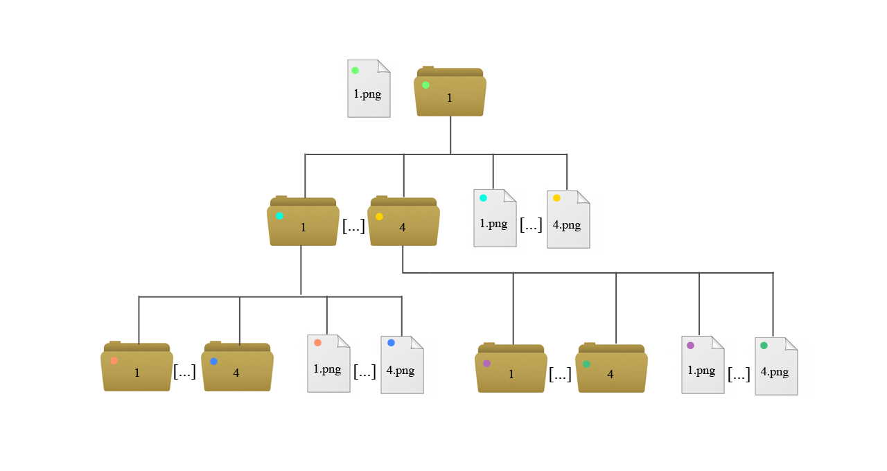
The TREE addressing-scheme is as easy as the WMTS addressing scheme. Every level in the tree defines a level of detail of the terrain. On level 0 we have an image (1.png) that represents the terrain in the worst quality. It has a folder that has its number as name (1). In this folder we find four images where all four images together represent the whole terrain. The resolution grows up every level by a factor of four. Every image has its folder that always includes four images with the next finer resolution quality. If an image has no folder, the final resolution quality has reached. The position of the images for a finer resolution is as follows:
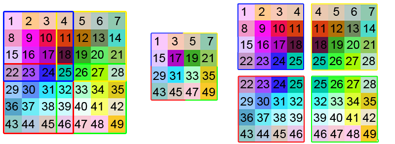
To reconstruct a 3D-Terrain from a WMTS conform dataset a special arrangement of the pixels in the images of the WMTS dataset is required. Neighboring tiles have to share the pixels on the boundaries. The figure on top of this subsection shows on the left the original image, in the middle the image of level 0 of the final dataset and on the right the four images of level 1. Furthermore the resolution of every image of the final dataset must be of the size 2n + 1, where n is the value of the size attribute of a tile in the BVHRefiner node. In the example of Puget Sound on top of this tutorial a value of ‘64 64’ is chosen for every tile as size attribute. So on the dataset, every image has to be of the size ‘129 129’. This is a condition for the algorithm to prevent cracks on the mesh representation.
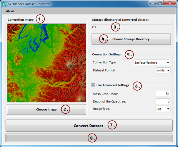
The BVHRefiner Dataset Converter is a tool to produce a WMTS or TREE conform dataset from single image. This is only a test application and can not handle arbitrary picture sizes.
Get the exe: windows
Get the source code:source
 Display example HTML file